
LiDAR (Light Detection and Ranging) technology is reshaping industries by providing highly accurate 3D maps of the world around us. By emitting laser pulses and measuring their return, LiDAR sensors create detailed point clouds that offer unprecedented precision. This technology has become a cornerstone of modern innovation, with transformative applications in autonomous vehicles, agriculture, urban planning, and environmental science.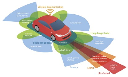 In self-driving cars, LiDAR serves as the "eyes" of the vehicle, enabling real-time object detection and navigation, which is critical for safety. In agriculture, it helps create detailed topographic maps to optimize crop management and irrigation, promoting sustainable farming. Urban planners use LiDAR to generate high-resolution 3D models of cities for infrastructure development and disaster preparedness. Meanwhile, environmental scientists rely on it to monitor deforestation, track ecosystem changes, and assess the impacts of climate change. As LiDAR systems become more compact, affordable, and powerful, their potential to revolutionize how we understand and interact with our environment continues to grow, driving us toward a smarter, more efficient future.
In self-driving cars, LiDAR serves as the "eyes" of the vehicle, enabling real-time object detection and navigation, which is critical for safety. In agriculture, it helps create detailed topographic maps to optimize crop management and irrigation, promoting sustainable farming. Urban planners use LiDAR to generate high-resolution 3D models of cities for infrastructure development and disaster preparedness. Meanwhile, environmental scientists rely on it to monitor deforestation, track ecosystem changes, and assess the impacts of climate change. As LiDAR systems become more compact, affordable, and powerful, their potential to revolutionize how we understand and interact with our environment continues to grow, driving us toward a smarter, more efficient future.